The 5 Regions of Alaska
The 5 Regions of Alaska II Image by The State of Alaska
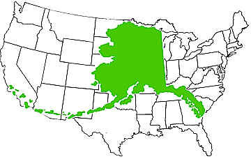
Alaska is an enormous state. It’s a fact. It is the largest state in the United States of America, containing 663,300 square miles of land (compared to Texas, which comes in at 268,596 square miles). If you set Alaska on top of a map of the Lower 48, it would reach from the west to the east coast and cover most of the Midwest.
Alaska over the United States II Image by The State of Alaska
When people visit Alaska for the first time, they are often stunned by the distance between locations. We want to share this information so that you are not caught off guard when planning your trip and somehow find yourself driving 10 hours in a single day!
Alaska has five main regions: the Far North, Interior, Southwest, Southcentral, and Southeast. Each region is unique in its history, culture, nature, and landscape.
The Far North
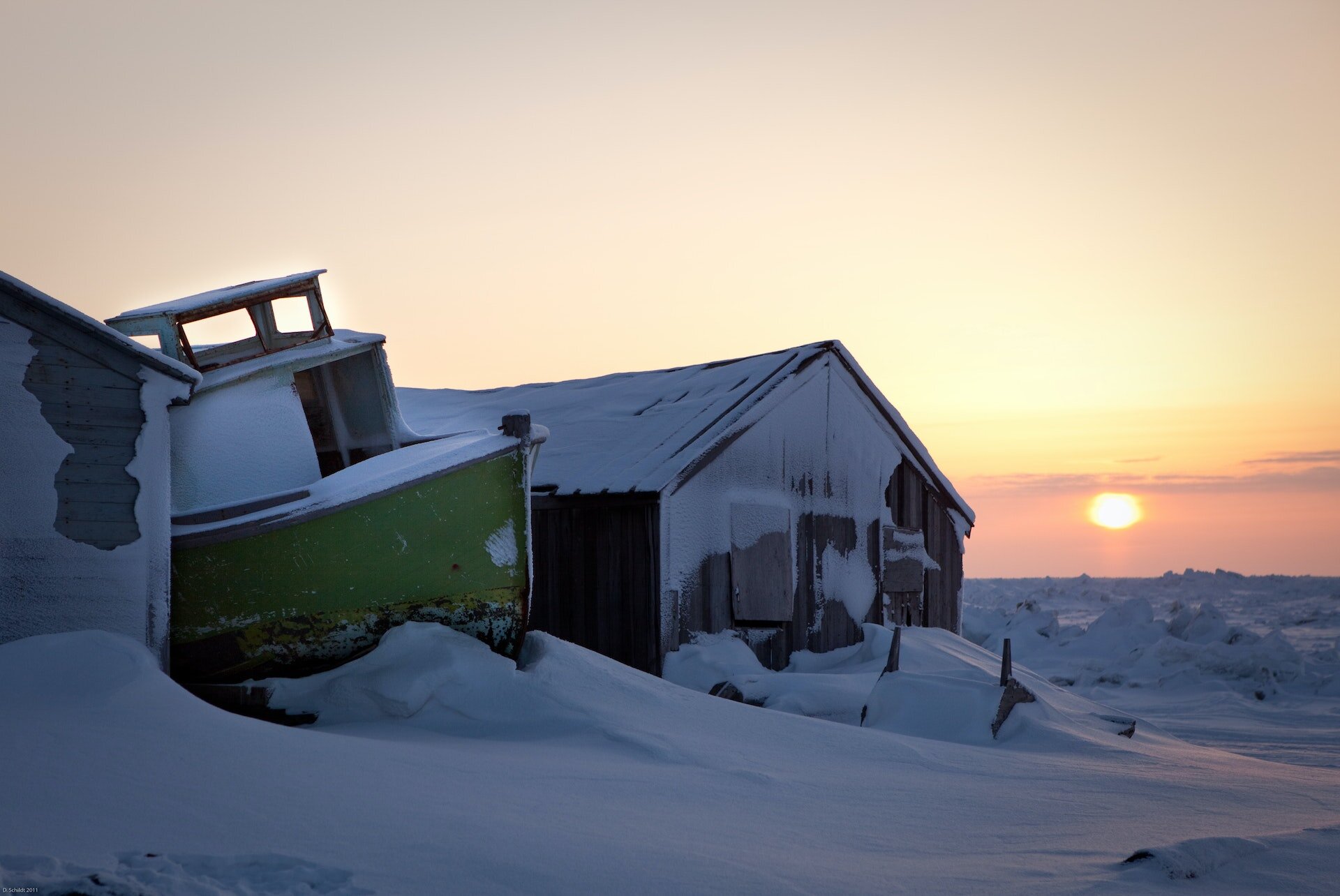
Winter scene in Utqiagvik, Alaska
The Far North region of Alaska is comprised of the Arctic Circle, the North Slope, and the Brooks Range. This area is the original home of the Inupiat Eskimos. The population of this entire region is just over 10,000 people.
There are two National Parks in this area, including Gates of the Arctic and Kobuk Valley National Park, and two National Preserves, including Noatak and Bering Land Bridge. Park rangers do not maintain these parks.
The main towns in this region are Utqiagvik (formerly Barrow), Nome, Kotzebue, Anaktuvuk Pass, Bettles, and Fort Yukon. Utqiagvik is the farthest north town in the United States and has 24 hours of sun for about 75 days in the summer and 24 hours of darkness for about 60 days in the winter.
There is one road to access this region, The Dalton Highway, which is mainly used by truckers traveling from the North Slope. This road is mostly unpaved, and most rental car companies prohibit driving. The best way to explore this region is from a bus tour out of Fairbanks or a bush plane flight.
The Interior
Northern Lights as seen from Fairbanks, Alaska
The Interior of Alaska was home to the Athabaskan people before the Alaska Gold Rush began in the late 1800s. Since the gold rush ended, the area has been sustained by military bases, the oil industry, and tourism. The main city in this region is Fairbanks, which is the second largest city in Alaska. Fairbanks is located beneath the Aurora Belt, making it one of the best places in the world to see the northern lights. There are also popular hot springs around Fairbanks, which make this area a popular winter destination.
Read more about how to view the northern lights in Alaska.
The Yukon River flows almost 2,000 miles across Interior Alaska and Canada. Denali National Park is located in the Interior, which contains Denali — the tallest mountain in North America at 20,320 feet. Denali is also home to incredible wildlife, including grizzly bears, caribou, wolves, and Dall sheep.
Fairbanks is a six-and-a-half-hour car ride from Anchorage (if you don’t make any stops). The main highways running through Fairbanks are the Parks Highway (Fairbanks to Wasilla), the Richardson Highway (Fairbanks to Valdez), and the Alaska Highway (from Fairbanks to the Canadian Border). Fairbanks can also be reached by the Alaska Railroad and plane.
Southwest
Brown bears fishing in Southwest Alaska
The Southwest region of Alaska includes the Aleutian Islands, the Yukon and Kuskokwim River deltas, and the Alaska Peninsula. The communities in this region are primarily Native Alaskan villages, including people from the Aleut, Alutiiq, and Yupik tribes. The Yupik community of Bethel is a major center for villages located on the Yukon and Kuskokwim river deltas.
This area is part of the Pacific Ocean’s “Ring of Fire,” which contain many volcanoes. Many of the volcanoes in this area are still active. The largest volcanic eruption happened at Novarupta Volcano in Katmai National Park in 1912.
This region has two National Parks — Lake Clark National Park and Katmai National Park. Both of these parks are known for their fishing and bear viewing. Many brown bears make their home around Brooks Falls, McNeil River, and Lake Clark, attracting travelers worldwide. In McNeil River State Game Sanctuary, up to 2,500 bears gather to feed on salmon in the summer. Over 230 species of birds travel to the Aleutian chain, the longest archipelago of small islands in the world.
No roads connect Southwest Alaska with the rest of the state. This region has limited ferry service, so most locals and visitors will arrive by plane from Anchorage or Homer. Many private lodges in this area can be accessed by bush and float planes.
Read more about visiting Brooks Falls in Katmai National Park.
Southcentral
View of Downtown Anchorage in winter
Southcentral is the main region in the state of Alaska. Not only is Anchorage, the largest city in the state, located here, but the area is also home to incredible nature, wildlife, National Parks, and more.
Though it may seem like this area of Alaska is compact, don’t be fooled. The drive from Talkeetna to Homer is over 6 hours (without making stops). Wrangell - St. Elias is the largest National Park in the United States. It is the same size as Yellowstone National Park, Yosemite National Park, and Switzerland combined! It also has 9 of the 16 tallest mountains in the US.
The world-famous Iditarod Sled Dog Race takes place here in March, with the ceremonial start occurring in Anchorage and the official start in Willow the following day. Alyeska Ski Resort, located in Girdwood (a 45-minute drive from Anchorage), is popular for downhill and backcountry skiing.
Many people will fly into Anchorage International Airport when they arrive in Alaska. Those travelers who take a cruise to Alaska will often finish their cruise in Whittier or Seward. Other popular towns in this region are Talkeetna, Seward, Homer, and Valdez. It is easy to drive, fly, boat, or travel by train around this region. The Seward Highway and the Glenn Highway are nationally recognized Scenic Byways.
Read more about what to do in Anchorage, Alaska.
Southeast
Ketchikan, Alaska
Southeast Alaska is also often called the Panhandle and the Inside Passage because the ocean channels are protected by islands. Many islands in this region run alongside the mainland, which makes it a popular area to explore by cruise ship. Admiralty Island is known for having the world's highest concentration of brown bears!
Some of the main towns in this region are Ketchikan, Sitka, and Juneau. Sitka was the original capital of Alaska when the land still belonged to Russia. Juneau, the current capital of Alaska, is located here and, fun fact, is the only capital in the United States not accessible by car. There are few roads that connect towns in this region. You can drive by car from Canada to Haines or Skagway. Otherwise, you must take a cruise ship, ferry, or flight to reach many of these places.
Southeast Alaska is primarily influenced by the Tlingit and Haida people who call this region home. The Alaska Gold Rush was also important in this region as gold miners founded Juneau and Skagway.
Read more about visiting Juneau, Alaska.
Visit Alaska
I hope this helps give you a little insight into the different areas of Alaska and better understand how large the state actually is. It may be too much to explore on one trip, but it will always give you a reason to come back for more.
If you have any questions about visiting Alaska, please contact us here. If you’re ready to start planning your trip, visit our Design Your Trip page!


